Automatic cloud-based monitoring for infrastructures and buildings
Automatic cloud-based monitoring for infrastructures and buildings.
Monitoring is essential to assessing and predicting landslides or ground structural weaknesses, which could affect buildings or infrastructures.
To get accurate information over areas subject to subsidence or slow moving landslides, in order to anticipate potential risks, is fundamental for organizations and professionals working in civil protection, master plan management and insurance.
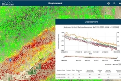
Rheticus® Displacement is a geoinformation service designed for the monitoring of earth's surface movements, aimed at monitoring areas subject to landslides and subsidence, and the stability of infrastructures.
Using European Copernicus Sentinel-1 open data or COSMO-SkyMed data images and persistent scatterers techniques, the service is complementary to traditional survey methods, providing a long-term solution to ground instability monitoring.
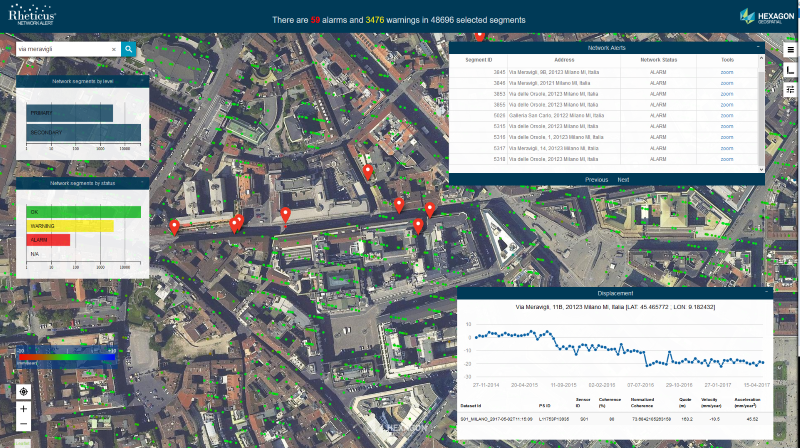
Rheticus® Displacement is a service of land monitoring designed for the monitoring of large area, which provides detailed information on:
- Check of slope stability due to slow landslides movements;
- Analysis of the presence of phenomena of instability in the preliminary and the final phase of the planning of works and infrastructures;
- Monitoring the impact of the works and infrastructures construction on the slope stability;
- Check of the results of the interventions of slope stabilization.
Visit www.rheticus.eu and ask for a LIVE DEMO.
 It is targeted to
Infrastructures and works managers and builders; Public Administration; Planners & professionals in the territory.
Applications
Timely identification of subsidence phenomena and landslides, optimization of on site monitoring activities, planning of emergency maintenance interventions.
Key Benefits
- Updated knowledge of ground conditions
- Continuous monitoring of landslide areas
- Limited cost of service management
- Safeguarding of investments
Rheticus: An award-winning service
Rheticus awarded with Hera Group use case at World Smart City Awards 2019.
A new reward for Rheticus®, the satellite based monitoring service developed by Planetek. The Hera multi-utility use case was awarded the "Urban Environment Award". Read more